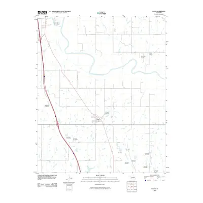
2010 Map of Wayne
USGS Topo · Published 2010About this map
The town of Wayne serves as the central hub of this McClain County landscape, situated where the terrain begins to slope toward the wide valley of the Canadian River. This 2010 survey highlights a sophisticated water management system throughout the countryside, evidenced by a dense network of flood control structures including Finn Creek Site 36 Dam, Owl Creek Site 1 Dam, and the C L Rose Lake Dam. These features reflect the region's adaptation to the local watershed and its agricultural needs.
Find a feature on this map
41 named features on this map. Tap any name to fly to it.
Don’t see what you’re looking for? This feature index may not catch every label — zoom into the map to look around manually.
Map Details
Editions of this 2010 Wayne Map
This is the sole edition of this map. No revisions or reprints were ever made.
Other maps of this area

1893 · Norman
USGS Topo · 1:62,500

1898 · Purcell
USGS Topo · 1:125,000

1898 · Pauls Valley
USGS Topo · 1:125,000

1902 · Pauls Valley
USGS Topo · 1:125,000

1910 · McComb
USGS Topo · 1:62,500

1936 · Norman
USGS Topo · 1:62,500

1954 · Oklahoma City
USGS Topo · 1:250,000

1957 · Ardmore
USGS Topo · 1:250,000

1957 · Oklahoma City
USGS Topo · 1:250,000
1958 · Eason
USGS Topo · 1:24,000