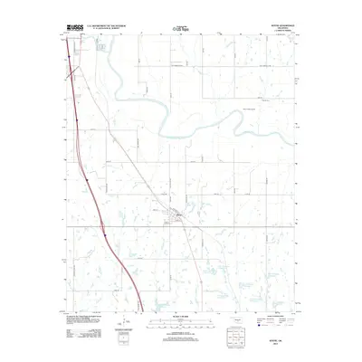
2012 Map of Wayne
USGS Topo · Published 2012About this map
Wayne serves as the central hub of this McClain County landscape, where the town's street grid is neatly framed by Railroad St, Beck St, and Lewis St. The surrounding geography is defined by the sweeping curves of the Canadian River and an extensive network of managed water resources, including a series of designated flood control structures such as Owl Creek Site 1 Reservoir and the Wayne Creek Site 1 Reservoir. This system of reservoirs and small creeks like Gaddis Cr and W Owl Cr illustrates the intensive water management required in the region's agricultural and prairie environment. To the northeast, the West Corbett Oil Field and the Denton Cem provide evidence of the dual legacy of resource extraction and early settlement that shaped this part of Oklahoma.
Find a feature on this map
49 named features on this map. Tap any name to fly to it.
Don’t see what you’re looking for? This feature index may not catch every label — zoom into the map to look around manually.
Map Details
Editions of this 2012 Wayne Map
This is the sole edition of this map. No revisions or reprints were ever made.
Other maps of this area

1893 · Norman
USGS Topo · 1:62,500

1898 · Purcell
USGS Topo · 1:125,000

1898 · Pauls Valley
USGS Topo · 1:125,000

1902 · Pauls Valley
USGS Topo · 1:125,000

1910 · McComb
USGS Topo · 1:62,500

1936 · Norman
USGS Topo · 1:62,500

1954 · Oklahoma City
USGS Topo · 1:250,000

1957 · Ardmore
USGS Topo · 1:250,000

1957 · Oklahoma City
USGS Topo · 1:250,000
1958 · Eason
USGS Topo · 1:24,000