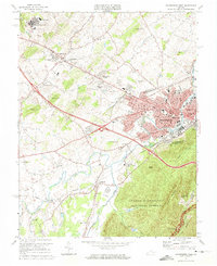
1973 Map of Waynesboro West
USGS Topo · Published 1974About this map
Waynesboro serves as the industrial and civic heart of this 1973 survey, situated where the South River winds past the Riverview Cem and several municipal landmarks. The map documents a period of significant educational and infrastructure footprint, notably the Woodrow Wilson Educational Center complex and the Wilson Memorial High Sch in the northwest. Beyond the urban center, the landscape transitions into the wooded slopes of the George Washington National Forest, bordered by the Blue Ridge Parkway and Stony Ridge.
Find a feature on this map
79 named features on this map. Tap any name to fly to it.
Don’t see what you’re looking for? This feature index may not catch every label — zoom into the map to look around manually.
Map Details
Editions of this 1973 Waynesboro West Map
4 editions found
Other maps of this area

1892 · Buckingham
USGS Topo · 1:125,000

1892 · Harrisonburg
USGS Topo · 1:125,000

1894 · Staunton
USGS Topo · 1:125,000

1894 · Lexington
USGS Topo · 1:125,000

1934 · Waynesboro
USGS Topo · 1:48,000

1936 · Vesuvius
USGS Topo · 1:48,000

1939 · Waynesboro
USGS Topo · 1:62,500

1941 · Vesuvius
USGS Topo · 1:62,500

1943 · Lovingston
USGS Topo · 1:62,500

1944 · Staunton
USGS Topo · 1:62,500