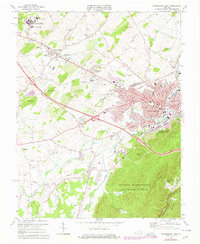
1973 Map of Waynesboro West
USGS Topo · Published 1978About this map
The industrial and suburban development of the western edge of Waynesboro is extensively documented in this mid-1970s revision. The city expands toward the foothills of the George Washington National Forest, where the Blue Ridge Parkway and Shenandoah Valley Overlook provide a clear vantage of the valley floor. Transportation corridors dominate the landscape, with the Chesapeake and Ohio and Norfolk and Western railroads bisecting the region, passing through growing communities like Fishersville and Ladd. The map shows a heavy concentration of educational and civic institutions, from the Woodrow Wilson Educational Center to local landmarks like Tinkling Spring Ch and the Waynesboro Airport. The inclusion of various industrial sites, such as the Sewage Disposal and an Industrial Waste Pond along the South River, reflects the post-war economic character of the Augusta County borderlands.
Find a feature on this map
78 named features on this map. Tap any name to fly to it.
Don’t see what you’re looking for? This feature index may not catch every label — zoom into the map to look around manually.
Map Details
Editions of this 1973 Waynesboro West Map
4 editions found
Other maps of this area

1892 · Buckingham
USGS Topo · 1:125,000

1892 · Harrisonburg
USGS Topo · 1:125,000

1894 · Staunton
USGS Topo · 1:125,000

1894 · Lexington
USGS Topo · 1:125,000

1934 · Waynesboro
USGS Topo · 1:48,000

1936 · Vesuvius
USGS Topo · 1:48,000

1939 · Waynesboro
USGS Topo · 1:62,500

1941 · Vesuvius
USGS Topo · 1:62,500

1943 · Lovingston
USGS Topo · 1:62,500

1944 · Staunton
USGS Topo · 1:62,500