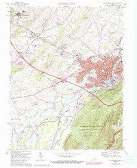
1973 Map of Waynesboro West
USGS Topo · Published 1987About this map
The industrial and residential growth of Waynesboro dominates this mid-1970s landscape, where the South River winds through a dense network of neighborhoods and manufacturing sites. The map documents an area in transition, featuring the extensive educational campus of the Woodrow Wilson Educational Center and the Valley Vocational Sch near Fishersville. Cultural landmarks of the era are clearly visible, from the Aero-Drive Inn and a Drive-in Theater to the local Waynesboro Airport.
Find a feature on this map
83 named features on this map. Tap any name to fly to it.
Don’t see what you’re looking for? This feature index may not catch every label — zoom into the map to look around manually.
Map Details
Editions of this 1973 Waynesboro West Map
4 editions found
Other maps of this area

1892 · Buckingham
USGS Topo · 1:125,000

1892 · Harrisonburg
USGS Topo · 1:125,000

1894 · Staunton
USGS Topo · 1:125,000

1894 · Lexington
USGS Topo · 1:125,000

1934 · Waynesboro
USGS Topo · 1:48,000

1936 · Vesuvius
USGS Topo · 1:48,000

1939 · Waynesboro
USGS Topo · 1:62,500

1941 · Vesuvius
USGS Topo · 1:62,500

1943 · Lovingston
USGS Topo · 1:62,500

1944 · Staunton
USGS Topo · 1:62,500