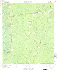
1978 Map of Waynesville
USGS Topo · Published 1978About this map
The Satilla River meanders through this portion of Georgia, defining a landscape dominated by riverine oxbows and expansive wetlands like Seals Bay and Brailey Swamp. Settlement centers on Waynesville and Atkinson, where the Seaboard Coast Line railroad dictates the local geometry of the land. Further south, the former path of industry is marked by an Old Railroad Grade cutting across the terrain toward Linda Plantation. For local historians and genealogists, the map is remarkably dense with family-named landmarks and rural burial grounds, including Wiggens Cem, Highsmith Cem, and the Pilgrims Rest Cem Ch. The presence of several Indian Mounds and the Ammons Ferry crossing suggests layers of long-term human activity along the river's shifting banks, from early indigenous sites to the era of river-based transport and plantation agriculture.
Find a feature on this map
64 named features on this map. Tap any name to fly to it.
Don’t see what you’re looking for? This feature index may not catch every label — zoom into the map to look around manually.
Map Details
Editions of this 1978 Waynesville Map
This is the sole edition of this map. No revisions or reprints were ever made.
Other maps of this area

1917 · Nahunta
USGS Topo · 1:62,500

1918 · Hortense
USGS Topo · 1:62,500

1918 · Everett City
USGS Topo · 1:62,500

1918 · Nahunta
USGS Topo · 1:62,500

1918 · Bladen
USGS Topo · 1:62,500

1920 · Everett City
USGS Topo · 1:62,500

1939 · Bladen
USGS Topo · 1:62,500

1944 · Everett City
USGS Topo · 1:62,500

1944 · Hortense
USGS Topo · 1:62,500

1946 · Brunswick
USGS Topo · 1:250,000