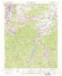
1941 Map of Waynesville
USGS Topo · Published 1969About this map
Waynesville and Hazelwood serve as the hub of activity in this high-altitude landscape of Haywood County, where the valley floor transitions into the protected peaks of the Pisgah National Forest. The local economy of the 1940s is traced through the Southern Railway corridor and the industrial presence of the Big Ridge Mine. Religious and community life are anchored by landmarks like Elizabeth Chapel and the Greenhill Cem, while the rugged southern terrain is defined by the Sherwood Wildlife Management Area.
Find a feature on this map
80 named features on this map. Tap any name to fly to it.
Don’t see what you’re looking for? This feature index may not catch every label — zoom into the map to look around manually.
Map Details
Editions of this 1941 Waynesville Map
3 editions found
Other maps of this area

1891 · Cowee
USGS Topo · 1:125,000

1893 · Mt Guyot
USGS Topo · 1:125,000

1894 · Asheville
USGS Topo · 1:125,000

1897 · Cowee
USGS Topo · 1:125,000

1901 · Asheville
USGS Topo · 1:125,000

1905 · Pisgah
USGS Topo · 1:125,000

1906 · Pisgah
USGS Topo · 1:125,000

1907 · Cowee
USGS Topo · 1:125,000

1912 · Mt Guyot
USGS Topo · 1:125,000

1935 · Cruso
USGS Topo · 1:24,000