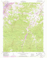
1941 Map of Waynesville
USGS Topo · Published 1980About this map
Waynesville and Hazelwood serve as the urban anchors of this Haywood County landscape, where the valley floor transitions into the high elevations of the Balsam Mountains. The 1941 survey, updated with late-1970s aerial data, reveals a community structured by water and rail, with the Southern RR following the curves of Richland Creek. While the towns show significant growth, the surrounding ridges like Lickstone Ridge and Roberson Ridge remain defined by rural landmarks such as Elizabeth Chapel and Francis Cove Ch.
Find a feature on this map
76 named features on this map. Tap any name to fly to it.
Don’t see what you’re looking for? This feature index may not catch every label — zoom into the map to look around manually.
Map Details
Editions of this 1941 Waynesville Map
3 editions found
Other maps of this area

1891 · Cowee
USGS Topo · 1:125,000

1893 · Mt Guyot
USGS Topo · 1:125,000

1894 · Asheville
USGS Topo · 1:125,000

1897 · Cowee
USGS Topo · 1:125,000

1901 · Asheville
USGS Topo · 1:125,000

1905 · Pisgah
USGS Topo · 1:125,000

1906 · Pisgah
USGS Topo · 1:125,000

1907 · Cowee
USGS Topo · 1:125,000

1912 · Mt Guyot
USGS Topo · 1:125,000

1935 · Cruso
USGS Topo · 1:24,000