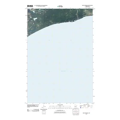
2010 Map of Wealthwood
USGS Topo · Published 2010About this map
Mille Lacs Lake dominates the southern landscape of this northern Minnesota quadrangle, its northern shoreline defining the limits of the settlement at Wealthwood. The geography here transitions from the expansive waters of the lake to a wetland-rich interior, where smaller bodies of water like Petes Lakes and Gregg Lake dot the terrain north of the shore. Cultural and communal landmarks are concentrated along the lakeside road network, including the lakeside Camp Kitchi Kahniss and the Black Cemetery located just east of the village. The prominent landform of Knox Point extends into the lake, marking a distinct point on the shoreline. Local transit is facilitated by rural routes such as Bobseen Blvd, 240th Ln, and 385th Ave, which connect the scattered homesteads and seasonal sites to the main lakeside thoroughfare.
Find a feature on this map
10 named features on this map. Tap any name to fly to it.
Don’t see what you’re looking for? This feature index may not catch every label — zoom into the map to look around manually.
Map Details
Editions of this 2010 Wealthwood Map
This is the sole edition of this map. No revisions or reprints were ever made.
Other maps of this area

1912 · Deerwood
USGS Topo · 1:62,500

1914 · Deerwood
USGS Topo · 1:62,500

1916 · Wealthwood
USGS Topo · 1:62,500

1953 · Duluth
USGS Topo · 1:250,000

1958 · Duluth
USGS Topo · 1:250,000

1968 · Onamia NW
USGS Topo · 1:24,000

1968 · Wahkon North
USGS Topo · 1:24,000
1968 · Vineland
USGS Topo · 1:24,000
1973 · Glen
USGS Topo · 1:24,000
1973 · Malmo
USGS Topo · 1:24,000