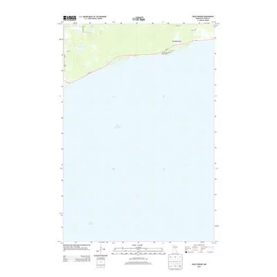
2013 Map of Wealthwood
USGS Topo · Published 2013About this map
Wealthwood serves as the focal point of this northern shore survey, where the township meets the expansive waters of Mille Lacs Lake. The settlement pattern here is tied closely to the shoreline, with the presence of Camp Kitchi Kahniss and the protruding Knox Point illustrating the area's long-standing orientation toward the water. To the north, the landscape transitions into a series of smaller water bodies, including Gregg Lake and the Petes Lakes cluster, separated by local routes like Bobsen Blvd and 240th LN. Genealogists will note the location of Black Cem, situated just north of the lakefront road. This modern digital survey provides a clear view of the rural infrastructure in Aitkin County, from the primary corridor of Us-169 to the residential streets that line the bay.
Find a feature on this map
13 named features on this map. Tap any name to fly to it.
Don’t see what you’re looking for? This feature index may not catch every label — zoom into the map to look around manually.
Map Details
Editions of this 2013 Wealthwood Map
This is the sole edition of this map. No revisions or reprints were ever made.
Other maps of this area

1912 · Deerwood
USGS Topo · 1:62,500

1914 · Deerwood
USGS Topo · 1:62,500

1916 · Wealthwood
USGS Topo · 1:62,500

1953 · Duluth
USGS Topo · 1:250,000

1958 · Duluth
USGS Topo · 1:250,000

1968 · Onamia NW
USGS Topo · 1:24,000

1968 · Wahkon North
USGS Topo · 1:24,000
1968 · Vineland
USGS Topo · 1:24,000
1973 · Glen
USGS Topo · 1:24,000
1973 · Malmo
USGS Topo · 1:24,000