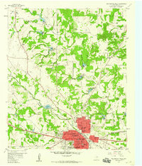
1959 Map of Weatherford North
USGS Topo · Published 1960About this map
Weatherford anchors the southern portion of this Parker County landscape, showing the city's mid-century footprint centered on the Courthouse and the intersection of the Texas and Pacific railroad. The map documents a transition from the urban core—home to Weatherford College and Campbell Memorial Hospital—to the outlying ranching and agricultural lands of the north. Significant water management is evident through a numbered series of reservoirs, including Res No 24 and Res No 30, alongside natural landmarks like Sunshine Lake. Local genealogy and community history are well-preserved through numerous rural institutions such as Zion Hill Ch, Shady Grove Ch, and Mt Carmel Cem. The road network is particularly notable for its variety, featuring the World War II Highway and Estel Rd reaching toward small outlying settlements like Peaster and Greenwood.
Find a feature on this map
49 named features on this map. Tap any name to fly to it.
Don’t see what you’re looking for? This feature index may not catch every label — zoom into the map to look around manually.
Map Details
Editions of this 1959 Weatherford North Map
2 editions found
Other maps of this area

1891 · Weatherford
USGS Topo · 1:125,000

1893 · Weatherford
USGS Topo · 1:125,000

1931 · Dennis
USGS Topo · 1:62,500

1932 · Springtown
USGS Topo · 1:62,500

1954 · Dallas
USGS Topo · 1:250,000

1958 · Dallas
USGS Topo · 1:250,000

1958 · Springtown
USGS Topo · 1:24,000
1959 · Lake Weatherford
USGS Topo · 1:24,000
1959 · Weatherford North
USGS Topo · 1:24,000
1959 · Brock
USGS Topo · 1:24,000