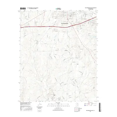
2016 Map of Weatherford South
USGS Topo · Published 2016About this map
The Weatherford Coll campus and the southern neighborhoods of Weatherford anchor the northern section of this Parker County landscape. The terrain south of the city is defined by a dense network of tributaries including Sanchez Cr, Threemile Br, and Black Warrior Br, which carve through the undulating topography. In the southern half of the quadrangle, the residential development of Western Lake sits near the winding course of Mill Cr. Small rural centers and family landmarks remain central to the area's geography, such as the Harmony community and several local burial grounds like Harmony Cem and Blackwell Cem. Aviation interest is represented by the Post Oak Airfield, while the presence of Hill Crest Gem and Lake Moncrief illustrates the local water management and recreational features that shaped the county's growth by the mid-2010s.
Find a feature on this map
137 named features on this map. Tap any name to fly to it.
Don’t see what you’re looking for? This feature index may not catch every label — zoom into the map to look around manually.
Map Details
Editions of this 2016 Weatherford South Map
This is the sole edition of this map. No revisions or reprints were ever made.
Other maps of this area

1891 · Weatherford
USGS Topo · 1:125,000

1893 · Weatherford
USGS Topo · 1:125,000

1924 · Weatherford 3-d
USGS Topo · 1:48,000

1931 · Dennis
USGS Topo · 1:62,500

1932 · Springtown
USGS Topo · 1:62,500

1954 · Dallas
USGS Topo · 1:250,000

1958 · Dallas
USGS Topo · 1:250,000
1958 · Chapin
USGS Topo · 1:24,000
1959 · Lake Weatherford
USGS Topo · 1:24,000
1959 · Tin Top
USGS Topo · 1:24,000