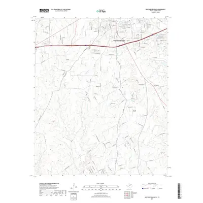
2019 Map of Weatherford South
USGS Topo · Published 2019About this map
Weatherford and the rural southern reaches of Parker County are defined by a complex network of creeks and branches that drain toward the south and east. Numerous seasonal and permanent waterways like Sanchez Cr and E Sanchez Cr carve through the landscape, while Clear Lakes provides a rare localized water feature in the northeast. The transition from the urban grid of the county seat to the agricultural and residential community of Harmony illustrates the region's mid-century and modern development patterns.
Find a feature on this map
143 named features on this map. Tap any name to fly to it.
Don’t see what you’re looking for? This feature index may not catch every label — zoom into the map to look around manually.
Map Details
Editions of this 2019 Weatherford South Map
This is the sole edition of this map. No revisions or reprints were ever made.
Other maps of this area

1891 · Weatherford
USGS Topo · 1:125,000

1893 · Weatherford
USGS Topo · 1:125,000

1924 · Weatherford 3-d
USGS Topo · 1:48,000

1931 · Dennis
USGS Topo · 1:62,500

1932 · Springtown
USGS Topo · 1:62,500

1954 · Dallas
USGS Topo · 1:250,000

1958 · Dallas
USGS Topo · 1:250,000
1958 · Chapin
USGS Topo · 1:24,000
1959 · Lake Weatherford
USGS Topo · 1:24,000
1959 · Tin Top
USGS Topo · 1:24,000