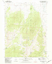
1981 Map of Weaver Canyon
USGS Topo · Published 1981About this map
Spring Creek Mountain and the South Mountains dominate this high-desert landscape along the border of Nevada and Utah. Recorded in 1981, the topography is defined by deep incisions like Weaver Canyon and Sanford Canyon, where intermittent water sources provided the only reliable anchors for human activity. Small-scale mining and ranching interests are evident at the Lucky Strike Mine, the Bismark Mine, and the ranch at Thomas Place.
Find a feature on this map
41 named features on this map. Tap any name to fly to it.
Don’t see what you’re looking for? This feature index may not catch every label — zoom into the map to look around manually.
Map Details
Editions of this 1981 Weaver Canyon Map
This is the sole edition of this map. No revisions or reprints were ever made.
Other maps of this area

1908 · Fish Springs
USGS Topo · 1:250,000

1910 · Fish Springs
USGS Topo · 1:250,000

1953 · Delta
USGS Topo · 1:250,000

1956 · Ely
USGS Topo · 1:250,000

1958 · Delta
USGS Topo · 1:250,000

1959 · Ely
USGS Topo · 1:250,000

1961 · Trout Creek
USGS Topo · 1:62,500

1962 · Delta
USGS Topo · 1:250,000

1963 · Ely
USGS Topo · 1:250,000
1972 · Ibapah Peak
USGS Topo · 1:24,000