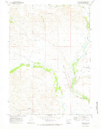
1970 Map of Webb Draw
USGS Topo · Published 1973About this map
The Old Fort Bonneville Site anchors the southeastern corner of this landscape, marking a historical crossroads where the Green River meets Prairie Creek. In 1970, this region of Sublette County showcases a transition from the elevated Beaver Ridge in the north down toward the alluvial expanses of Forty Rod Flat. The river's winding course is mirrored by local water management and ranching infrastructure, including the Scott Ditch and numerous gaging stations. Evidence of local settlement and community history appears in the Wilhelm Cem and the State Fish Hatchery located east of Forty Rod Road. Terrain features like Ryegrass and the Aspen Ridge Pit Reservoir indicate a land shaped by both natural drainage from Webb Draw and intentional water storage for agricultural use.
Find a feature on this map
20 named features on this map. Tap any name to fly to it.
Don’t see what you’re looking for? This feature index may not catch every label — zoom into the map to look around manually.
Map Details
Editions of this 1970 Webb Draw Map
This is the sole edition of this map. No revisions or reprints were ever made.
Other maps of this area

1907 · Gros Ventre
USGS Topo · 1:125,000

1910 · Gros Ventre
USGS Topo · 1:125,000

1939 · Big Piney
USGS Topo · 1:125,000

1942 · Big Piney
USGS Topo · 1:125,000

1955 · Driggs
USGS Topo · 1:250,000

1955 · Preston
USGS Topo · 1:250,000

1958 · Driggs
USGS Topo · 1:250,000

1958 · Preston
USGS Topo · 1:250,000

1962 · Driggs
USGS Topo · 1:250,000

1962 · Preston
USGS Topo · 1:250,000