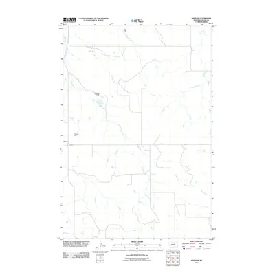
2011 Map of Webster
USGS Topo · Published 2011About this map
The small settlement of Webster serves as the primary focal point of this Fallon County survey, situated at the junction of Rte-247 in a landscape defined by intermittent watercourses and ranching infrastructure. The drainage patterns are clearly delineated, with Chimney Creek winding through the western portion of the quadrangle and Soda Creek and Mud Creek appearing to the east.
Find a feature on this map
10 named features on this map. Tap any name to fly to it.
Don’t see what you’re looking for? This feature index may not catch every label — zoom into the map to look around manually.
Map Details
Editions of this 2011 Webster Map
This is the sole edition of this map. No revisions or reprints were ever made.
Other maps of this area

1953 · Miles City
USGS Topo · 1:250,000
1954 · Ekalaka
USGS Topo · 1:250,000
1956 · Ekalaka
USGS Topo · 1:250,000
1957 · Miles City
USGS Topo · 1:250,000
1958 · Miles City
USGS Topo · 1:250,000
1958 · Ekalaka
USGS Topo · 1:250,000
1965 · Ekalaka
USGS Topo · 1:250,000
1980 · Dutchmans Hill
USGS Topo · 1:24,000
1980 · Flasted Hill
USGS Topo · 1:24,000
1980 · Snider Hill
USGS Topo · 1:24,000