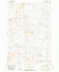
1980 Map of Flasted Hill
USGS Topo · Published 1980About this map
Flasted Hill rises above a landscape defined by the winding drainages of the North Fork Coal Bank Creek and South Fork Coal Bank Creek in the eastern Montana plains. This 1980 survey reveals a quiet ranching and resource territory straddling the boundary of Fallon and Carter counties. The map documents an environment where water management is paramount to the local economy, evidenced by numerous scattered wells and tanks situated across the drainages of Squabble Creek and Horse Creek. Apart from a solitary Gravel Pit, the land remains primarily characterized by its natural contours and the seasonal flow of Flasted Creek, illustrating the persistent rural character of this border region in the late twentieth century.
Find a feature on this map
12 named features on this map. Tap any name to fly to it.
Don’t see what you’re looking for? This feature index may not catch every label — zoom into the map to look around manually.
Map Details
Editions of this 1980 Flasted Hill Map
2 editions found
Other maps of this area

1953 · Miles City
USGS Topo · 1:250,000

1954 · Ekalaka
USGS Topo · 1:250,000

1956 · Ekalaka
USGS Topo · 1:250,000

1957 · Miles City
USGS Topo · 1:250,000

1958 · Miles City
USGS Topo · 1:250,000

1958 · Ekalaka
USGS Topo · 1:250,000

1965 · Ekalaka
USGS Topo · 1:250,000

1980 · Dutchmans Hill
USGS Topo · 1:24,000
1980 · Lampkin Gulch
USGS Topo · 1:24,000
1980 · Humbolt Hills
USGS Topo · 1:24,000