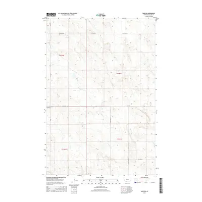
2017 Map of Webster
USGS Topo · Published 2017About this map
Webster stands as the primary settlement in this corner of Fallon County, positioned at the intersection of State Hwy 322 and Webster Rd. The landscape is defined by the drainage patterns of seasonal watercourses, most notably the winding paths of Chimney Cr, Soda Cr, and Mud Cr. These creek beds dictate the local road network, with routes like Chimney Creek Rd and Soda Creek RD tracing the low-lying terrain between elevated ridges. The township and range lines of t4n r60e and surrounding sections highlight the orderly grid of Montana's high plains, where large-scale ranching and agriculture are facilitated by thoroughfares such as Little Beaver Rd and 101 Rd.
Find a feature on this map
14 named features on this map. Tap any name to fly to it.
Don’t see what you’re looking for? This feature index may not catch every label — zoom into the map to look around manually.
Map Details
Editions of this 2017 Webster Map
This is the sole edition of this map. No revisions or reprints were ever made.
Other maps of this area

1953 · Miles City
USGS Topo · 1:250,000

1954 · Ekalaka
USGS Topo · 1:250,000

1956 · Ekalaka
USGS Topo · 1:250,000

1957 · Miles City
USGS Topo · 1:250,000

1958 · Miles City
USGS Topo · 1:250,000

1958 · Ekalaka
USGS Topo · 1:250,000

1965 · Ekalaka
USGS Topo · 1:250,000

1980 · Dutchmans Hill
USGS Topo · 1:24,000
1980 · Flasted Hill
USGS Topo · 1:24,000
1980 · Snider Hill
USGS Topo · 1:24,000