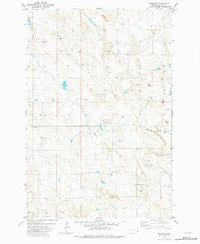
1981 Map of Webster
USGS Topo · Published 1981About this map
The small settlement of Webster serves as the focal point for this Fallon County landscape, situated along the upper reaches of Chimney Creek. This 1981 edition, based on earlier photogrammetric data, reflects the quiet rural infrastructure of eastern Montana during the late twentieth century. Education and navigation are marked by the presence of the Chimney Creek Sch and a remote Landing Strip, while the area's hydrology is defined by seasonal drainages like Soda Creek and Mud Creek. The map documents a territory heavily shaped by resource management and communication, evidenced by numerous wells, a Flowing Well, a Gravel Pit, and a localized Radio Tower. These features indicate a terrain where scattered homesteads and ranching operations relied on subsurface water and basic aerial transit to maintain connectivity across the drainage basins.
Find a feature on this map
14 named features on this map. Tap any name to fly to it.
Don’t see what you’re looking for? This feature index may not catch every label — zoom into the map to look around manually.
Map Details
Editions of this 1981 Webster Map
This is the sole edition of this map. No revisions or reprints were ever made.
Other maps of this area

1953 · Miles City
USGS Topo · 1:250,000

1954 · Ekalaka
USGS Topo · 1:250,000

1956 · Ekalaka
USGS Topo · 1:250,000

1957 · Miles City
USGS Topo · 1:250,000

1958 · Miles City
USGS Topo · 1:250,000

1958 · Ekalaka
USGS Topo · 1:250,000

1965 · Ekalaka
USGS Topo · 1:250,000

1980 · Dutchmans Hill
USGS Topo · 1:24,000
1980 · Flasted Hill
USGS Topo · 1:24,000
1980 · Snider Hill
USGS Topo · 1:24,000