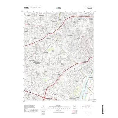
2017 Map of Webster Groves
USGS Topo · Published 2017About this map
Jefferson Barracks National Cemetery and the adjacent Jefferson Barracks anchor the southeastern corner of this suburban landscape where the Mississippi River forms the state boundary. This area of St. Louis County is characterized by a dense network of residential communities and institutional landmarks, including Webster Univ and both the Eden Theological Seminary and Kenrick-Glennon Seminary. The map reveals a significant concentration of commemorative spaces, from the Sappington Grave Yard to large modern grounds like Resurrection Cem and Sunset Burial Park. Historic preservation is centered at the Ulysses S Grant National Historic Site in Grantwood Village. The region's drainage is defined by the winding paths of Deer Cr and Gravois Cr, which flow through established neighborhoods like Webster Groves, Shrewsbury, and Crestwood, illustrating the mid-20th-century suburban expansion of the St. Louis metropolitan area.
Find a feature on this map
88 named features on this map. Tap any name to fly to it.
Don’t see what you’re looking for? This feature index may not catch every label — zoom into the map to look around manually.
Map Details
Editions of this 2017 Webster Groves Map
This is the sole edition of this map. No revisions or reprints were ever made.
Other maps of this area

1888 · St. Louis
USGS Topo · 1:62,500
1910 · Waterloo
USGS Topo · 1:62,500
1912 · Kimmswick
USGS Topo · 1:62,500
1913 · Waterloo
USGS Topo · 1:62,500
1916 · Kimmswick
USGS Topo · 1:62,500
1933 · Creve Coeur
USGS Topo · 1:24,000
1933 · Granite City
USGS Topo · 1:24,000
1933 · Jefferson Barracks
USGS Topo · 1:24,000
1933 · Cahokia
USGS Topo · 1:24,000
1933 · Clayton
USGS Topo · 1:24,000