1993 Map of Webster Groves
USGS Topo · Published 1996About this map
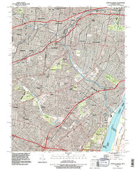
Jefferson Barracks and its associated county park anchor the southeastern riverfront of this suburban landscape, where the Mississippi River forms a natural border between Missouri and Illinois. The map illustrates a densely woven network of mid-century residential expansion and civic institutions across St Louis and its neighboring municipalities like Webster Groves and Richmond Heights. Notable for its high density of memorial sites, the area features massive grounds like Sunset Burial Park and Resurrection Cemetery, which alongside smaller plots like Old St Marcus Cemetery, offer significant resources for genealogical research.
Find a feature on this map
72 named features on this map. Tap any name to fly to it.
Don’t see what you’re looking for? This feature index may not catch every label — zoom into the map to look around manually.
Map Details
Editions of this 1993 Webster Groves Map
This is the sole edition of this map. No revisions or reprints were ever made.
Other maps of this area

1888 · St. Louis
USGS Topo · 1:62,500

1910 · Waterloo
USGS Topo · 1:62,500

1912 · Kimmswick
USGS Topo · 1:62,500

1913 · Waterloo
USGS Topo · 1:62,500

1916 · Kimmswick
USGS Topo · 1:62,500

1933 · Creve Coeur
USGS Topo · 1:24,000

1933 · Granite City
USGS Topo · 1:24,000

1933 · Jefferson Barracks
USGS Topo · 1:24,000

1933 · Cahokia
USGS Topo · 1:24,000

1933 · Clayton
USGS Topo · 1:24,000