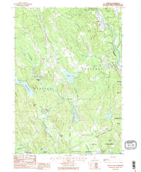
1987 Map of Webster
USGS Topo · Published 1987About this map
The confluence of the Blackwater River and the Warner River defines this New Hampshire landscape as it was mapped in the late 1980s. The region is marked by small settlements and historic crossroads such as Dingit Corner, Gerrish Corner, and Swetts Mills. The presence of the Blackwater Dam near the town of Webster reflects the management of the water system, while large bodies of water like Lake Winnepocket and Walker Pond punctuate the wooded terrain.
Find a feature on this map
54 named features on this map. Tap any name to fly to it.
Don’t see what you’re looking for? This feature index may not catch every label — zoom into the map to look around manually.
Map Details
Editions of this 1987 Webster Map
2 editions found
Other maps of this area

1926 · Hillsboro
USGS Topo · 1:62,500

1927 · Concord
USGS Topo · 1:62,500

1927 · Penacook
USGS Topo · 1:62,500

1928 · Mount Kearsarge
USGS Topo · 1:62,500

1929 · Hillsboro
USGS Topo · 1:62,500

1931 · Mount Kearsarge
USGS Topo · 1:62,500

1949 · Portland
USGS Topo · 1:250,000

1949 · Concord
USGS Topo · 1:62,500

1956 · Penacook
USGS Topo · 1:62,500

1956 · Mt. Kearsarge
USGS Topo · 1:62,500