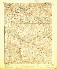
1918 Map of Webster Springs
USGS Topo · Published 1929About this map
Webster Springs (Addison) sits at the confluence of the Elk River and the Back Fork Elk River, serving as a central hub in a landscape defined by dramatic ridges and deep river valleys. The 1915 survey reveals a remarkably dense network of rural education, with schoolhouses such as Mill Run School, Redoak School, and Kingsley School positioned to serve isolated valley communities. This settlement pattern reflects the challenges of West Virginia's central highlands, where movement followed the winding paths of the Gauley River and Williams River. The topography is dominated by massive landforms like Point Mountain and the Gauley Divide, which separate the various watersheds. In the southern portion of the map, the boundary between Webster and Pocahontas Counties traverses high ridges, including Turkey Mountain, illustrating how natural terrain dictated political boundaries in this timber-rich region.
Find a feature on this map
105 named features on this map. Tap any name to fly to it.
Don’t see what you’re looking for? This feature index may not catch every label — zoom into the map to look around manually.
Map Details
Editions of this 1918 Webster Springs Map
4 editions found

Other maps of this area

1889 · Nicholas
USGS Topo · 1:125,000

1891 · Nicholas
USGS Topo · 1:125,000

1891 · Huntersville
USGS Topo · 1:125,000

1893 · Buckhannon
USGS Topo · 1:125,000

1893 · Sutton
USGS Topo · 1:125,000

1894 · Huntersville
USGS Topo · 1:125,000

1896 · Buckhannon
USGS Topo · 1:125,000

1897 · Buckhannon
USGS Topo · 1:125,000

1901 · Nicholas
USGS Topo · 1:125,000

1908 · Sutton
USGS Topo · 1:48,000
Featured Places
- Addison (Webster Springs), WV
- Webster Springs, Addison (Webster Springs)
- Curtin, WV
- Skidmore Crossing, WV
- Bolair, WV