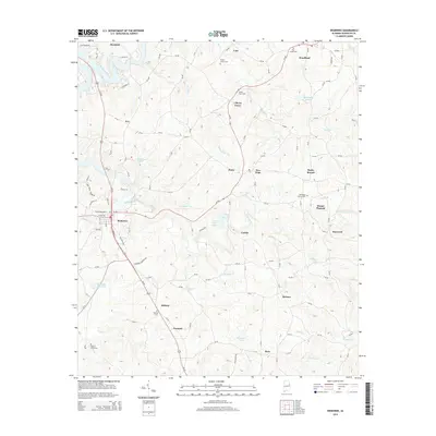
2014 Map of Wedowee
USGS Topo · Published 2014About this map
The Little Tallapoosa River flows through the northwest corner of this Randolph County landscape, where the town of Wedowee serves as a central hub. In the early 21st century, the area shows a pattern of rural settlements and agricultural land connected by a network of state and county roads, including Al-48 and Us-431. Small water bodies like Barton Lake, Carpenter Lake, and Wedowee Club Lake are scattered across the terrain, reflecting the region's managed water resources. For those researching family history, several burial sites are documented, such as the Traylor Family Cem and the Old Rocky Branch Cem near Rocky Branch. The map also captures several smaller communities like Woodland, Midway, and Liberty Grove, providing a clear view of the residential and road development patterns in this part of eastern Alabama.
Find a feature on this map
126 named features on this map. Tap any name to fly to it.
Don’t see what you’re looking for? This feature index may not catch every label — zoom into the map to look around manually.
Map Details
Editions of this 2014 Wedowee Map
This is the sole edition of this map. No revisions or reprints were ever made.
Other maps of this area

1891 · Ashland
USGS Topo · 1:125,000

1899 · Wedowee
USGS Topo · 1:125,000

1902 · Wedowee
USGS Topo · 1:125,000

1953 · Atlanta
USGS Topo · 1:250,000

1957 · Atlanta
USGS Topo · 1:250,000

1958 · Atlanta
USGS Topo · 1:250,000
1969 · Roanoke East
USGS Topo · 1:24,000

1969 · Wadley North
USGS Topo · 1:24,000
1969 · Newell
USGS Topo · 1:24,000
1969 · Napoleon
USGS Topo · 1:24,000