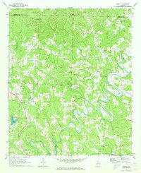
1969 Map of Newell
USGS Topo · Published 1973About this map
The Little Tallapoosa River carves a dramatic, winding path through this corner of Randolph County, defining the rural character of the late 1960s landscape. Small agricultural and residential hubs like Newell and Lamar serve as anchors for the surrounding hills, which are marked by a high density of country churches such as Antioch Ch and Mt Gilead Ch. The presence of small mines near Morrison Crossroads suggests a history of local resource extraction, while the Mt Carmel Sch and various local cemeteries point to the deeply rooted social fabric of these communities.
Find a feature on this map
33 named features on this map. Tap any name to fly to it.
Don’t see what you’re looking for? This feature index may not catch every label — zoom into the map to look around manually.
Map Details
Editions of this 1969 Newell Map
2 editions found
Other maps of this area

1889 · Tallapoosa
USGS Topo · 1:125,000

1891 · Ashland
USGS Topo · 1:125,000

1892 · Tallapoosa
USGS Topo · 1:125,000

1897 · Tallapoosa
USGS Topo · 1:125,000

1899 · Wedowee
USGS Topo · 1:125,000

1900 · Anniston
USGS Topo · 1:125,000

1902 · Wedowee
USGS Topo · 1:125,000

1953 · Atlanta
USGS Topo · 1:250,000

1957 · Atlanta
USGS Topo · 1:250,000

1958 · Atlanta
USGS Topo · 1:250,000