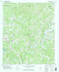
1969 Map of Newell
USGS Topo · Published 1973About this map
The Little Tallapoosa River carves a winding path through the borderlands of Cleburne and Randolph Counties in the late 1960s. This rural landscape is defined by its small crossroads settlements and a dense network of community landmarks. Morrison Crossroad and Newell serve as local hubs, while Gold Ridge and Lamar anchor the outlying districts. The presence of numerous spiritual and educational sites, such as Antioch Ch, Harmony Ch, and the Mt Carmel Sch, suggests a deeply rooted local culture centered on family and faith. Genealogists will find particular value in the distribution of cemeteries, including Old Cool Spring Cem and the Smyrna Cem. The economy of the era is evidenced by small-scale resource extraction, with a Mine near Wolf Creek and several Sandpits located along the river bends south of Mt Gilead Ch.
Find a feature on this map
45 named features on this map. Tap any name to fly to it.
Don’t see what you’re looking for? This feature index may not catch every label — zoom into the map to look around manually.
Map Details
Editions of this 1969 Newell Map
2 editions found
Other maps of this area

1889 · Tallapoosa
USGS Topo · 1:125,000

1891 · Ashland
USGS Topo · 1:125,000

1892 · Tallapoosa
USGS Topo · 1:125,000

1897 · Tallapoosa
USGS Topo · 1:125,000

1899 · Wedowee
USGS Topo · 1:125,000

1900 · Anniston
USGS Topo · 1:125,000

1902 · Wedowee
USGS Topo · 1:125,000

1953 · Atlanta
USGS Topo · 1:250,000

1957 · Atlanta
USGS Topo · 1:250,000

1958 · Atlanta
USGS Topo · 1:250,000