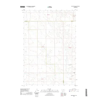
2020 Map of Weed Creek East
USGS Topo · Published 2020About this map
Butte Camp Rd cuts through a landscape defined by the intersection of three counties, marking the convergence of Yellowstone, Rosebud, and Treasure counties. This part of Montana is characterized by its drainage network, where Indian, Injun, and Alkali creeks weave between sharp topographic divides. The terrain is notably sculpted at Stove Coulee and across the high ground of Ruskosky Ridge, which rises above the southern drainages. The map records a classic western range pattern, where sparse road development like Butte Camp Rd provides the primary access across large tracts of open land, following the contours of the Weed Creek watershed.
Find a feature on this map
17 named features on this map. Tap any name to fly to it.
Don’t see what you’re looking for? This feature index may not catch every label — zoom into the map to look around manually.
Map Details
Editions of this 2020 Weed Creek East Map
This is the sole edition of this map. No revisions or reprints were ever made.
Other maps of this area

1954 · Forsyth
USGS Topo · 1:250,000

1957 · Forsyth
USGS Topo · 1:250,000

1958 · Forsyth
USGS Topo · 1:250,000

1962 · Guthridge Ranch
USGS Topo · 1:24,000

1962 · Sumatra
USGS Topo · 1:24,000

1963 · Melstone
USGS Topo · 1:24,000

1979 · Melstone
USGS Topo · 1:100,000

1979 · Hysham
USGS Topo · 1:100,000
1979 · Devils Kitchen
USGS Topo · 1:24,000
1980 · Weed Creek West
USGS Topo · 1:24,000