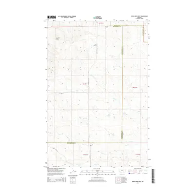
2014 Map of Weed Creek West
USGS Topo · Published 2014About this map
Cabin Creek Cem sits as a solitary landmark in this high-plains landscape, where the borders of Musselshell, Rosebud, and Yellowstone counties converge. The terrain is defined by a network of seasonal watercourses and drainage features, including the Angus Bell Coulee in the northwest and the winding paths of Weed Cr and Cabin Cr. This 2014 survey documents a territory shaped by ranching and early travel routes, evidenced by the Musselshell Trail Rd and the Melstone-Custer Rd. Rare water sources like Lemonade Spring and Rock Spring provide critical points of interest in an otherwise arid expanse. The map illustrates the continuing reliance on named springs and creek beds to navigate and manage this vast section of Big Sky Country, preserving the nomenclature of the original homesteaders and travelers who traversed these coulees.
Find a feature on this map
23 named features on this map. Tap any name to fly to it.
Don’t see what you’re looking for? This feature index may not catch every label — zoom into the map to look around manually.
Map Details
Editions of this 2014 Weed Creek West Map
This is the sole edition of this map. No revisions or reprints were ever made.
Other maps of this area

1954 · Forsyth
USGS Topo · 1:250,000

1957 · Forsyth
USGS Topo · 1:250,000

1958 · Forsyth
USGS Topo · 1:250,000

1962 · Queens Point
USGS Topo · 1:24,000

1962 · Guthridge Ranch
USGS Topo · 1:24,000

1963 · Melstone
USGS Topo · 1:24,000

1979 · Melstone
USGS Topo · 1:100,000

1979 · Hysham
USGS Topo · 1:100,000
1980 · Weed Creek West
USGS Topo · 1:24,000
1980 · Weed Creek East
USGS Topo · 1:24,000