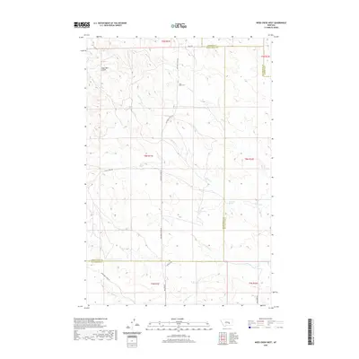
2020 Map of Weed Creek West
USGS Topo · Published 2020About this map
Cabin Creek Cem marks a lonely landmark in the northern reaches of this landscape where Yellowstone, Rosebud, and Musselshell counties converge. This high plains terrain is defined by a dendritic network of intermittent drainages, including Alkali Cr, Cabin Cr, and Weed Cr. Water sources like Lemonade Spring and Rock Spring provide critical points of interest in an otherwise arid environment primarily utilized for ranching. The road network, including the Musselshell Trail Rd and Melstone-Custer Rd, follows the natural contours of the land, connecting disparate ranch sites across the vast township and range sections. The map reveals the intersection of multiple survey townships, illustrating the late-period land division of rural Montana.
Find a feature on this map
24 named features on this map. Tap any name to fly to it.
Don’t see what you’re looking for? This feature index may not catch every label — zoom into the map to look around manually.
Map Details
Editions of this 2020 Weed Creek West Map
This is the sole edition of this map. No revisions or reprints were ever made.
Other maps of this area

1954 · Forsyth
USGS Topo · 1:250,000

1957 · Forsyth
USGS Topo · 1:250,000

1958 · Forsyth
USGS Topo · 1:250,000

1962 · Queens Point
USGS Topo · 1:24,000

1962 · Guthridge Ranch
USGS Topo · 1:24,000

1963 · Melstone
USGS Topo · 1:24,000

1979 · Melstone
USGS Topo · 1:100,000

1979 · Hysham
USGS Topo · 1:100,000
1980 · Weed Creek West
USGS Topo · 1:24,000
1980 · Weed Creek East
USGS Topo · 1:24,000