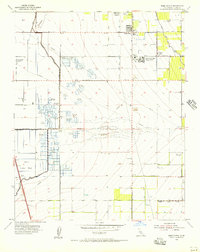
1955 Map of Weed Patch
USGS Topo · Published 1956About this map
The Arvin Farm Labor Supply Center and the surrounding agricultural landscape of Kern County dominate this mid-century survey. This area is characterized by a dense network of water management features, including the Central Branch Kern Island Canal and the Kern Island Drain, which support the intensive farming and ranching operations like Greenfield Ranch. A remarkable social feature of this map is the high concentration of private hunting clubs in the wetlands near Lake Paulina, such as the Rancho De Los Patos Duck Club, Spoon Bill Duck Club, and the evocatively named Dust Bowl Duck Club.
Find a feature on this map
50 named features on this map. Tap any name to fly to it.
Don’t see what you’re looking for? This feature index may not catch every label — zoom into the map to look around manually.
Map Details
Editions of this 1955 Weed Patch Map
3 editions found
Other maps of this area

1910 · Buena Vista Lake
USGS Topo · 1:125,000

1912 · Buena Vista Lake
USGS Topo · 1:125,000

1914 · Caliente
USGS Topo · 1:125,000

1929 · Fairfax School
USGS Topo · 1:31,680

1930 · Weed Patch
USGS Topo · 1:31,680

1930 · Arvin
USGS Topo · 1:31,680

1930 · Conner
USGS Topo · 1:31,680

1931 · West of Tejon Hills
USGS Topo · 1:31,680

1931 · Edison
USGS Topo · 1:31,680

1931 · Tejon Hills
USGS Topo · 1:31,680