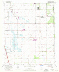
1955 Map of Weed Patch
USGS Topo · Published 1970About this map
Agricultural development and managed wetlands define this section of the San Joaquin Valley, where the Arvin Farm Labor Supply Center stands as a significant landmark of the region's labor history. The landscape is a network of irrigation and drainage infrastructure, including the Kern Island Canal and the New Rim Ditch, which redirect water across the former Kern Lake Bed. This 1955 survey reveals a specialized economy, with numerous private hunting grounds such as the Dust Bowl Duck Club, Spoon Bill Duck Club, and Webfoot Duck Club clustered around Lake Paulina. The transition from rural ranching at Greenfield Ranch to the growing community of Lamont is visible, along with local social anchors like the Sunset School and a Drive-in Theatre north of Weed Patch.
Find a feature on this map
47 named features on this map. Tap any name to fly to it.
Don’t see what you’re looking for? This feature index may not catch every label — zoom into the map to look around manually.
Map Details
Editions of this 1955 Weed Patch Map
3 editions found
Other maps of this area

1910 · Buena Vista Lake
USGS Topo · 1:125,000

1912 · Buena Vista Lake
USGS Topo · 1:125,000

1914 · Caliente
USGS Topo · 1:125,000

1929 · Fairfax School
USGS Topo · 1:31,680

1930 · Weed Patch
USGS Topo · 1:31,680

1930 · Arvin
USGS Topo · 1:31,680

1930 · Conner
USGS Topo · 1:31,680

1931 · West of Tejon Hills
USGS Topo · 1:31,680

1931 · Edison
USGS Topo · 1:31,680

1931 · Tejon Hills
USGS Topo · 1:31,680