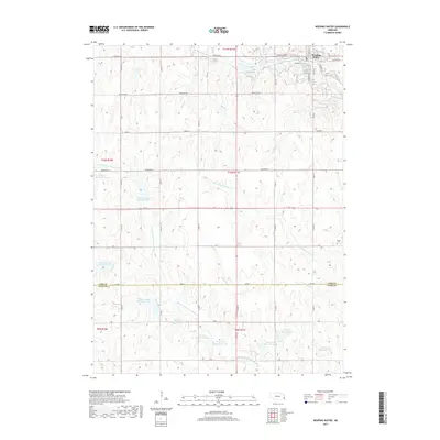
2017 Map of Weeping Water
USGS Topo · Published 2017About this map
Weeping Water occupies the northern reaches of this landscape, situated along the banks of Weeping Water Creek. The topography is defined by the rolling divides between multiple drainage systems, including the S Br Weeping Water Cr and the northern and southern forks of the Little Nemaha River. A significant system of managed water resources is evident throughout the southern half of the quadrangle, where numerous reservoirs such as Wilson Creek Reservoir 12-S, Wilson Cr Reservoir 12-11, and Wilson Creek Reservoir 11-A underscore the region's focus on agricultural water management and flood control. Near the eastern edge, the Avoca Cem serves as a quiet landmark on the boundary of Cass and Otoe counties, marking the intersection of family history and the rural landscape.
Find a feature on this map
39 named features on this map. Tap any name to fly to it.
Don’t see what you’re looking for? This feature index may not catch every label — zoom into the map to look around manually.
Map Details
Editions of this 2017 Weeping Water Map
This is the sole edition of this map. No revisions or reprints were ever made.
Other maps of this area

1903 · Weeping Water
USGS Topo · 1:125,000

1929 · Weeping Water
USGS Topo · 1:125,000

1955 · Lincoln
USGS Topo · 1:250,000
1956 · Weeping Water NE
USGS Topo · 1:24,000

1957 · Lincoln
USGS Topo · 1:250,000

1958 · Lincoln
USGS Topo · 1:250,000
1966 · Dunbar
USGS Topo · 1:24,000
1966 · Murdock
USGS Topo · 1:24,000
1966 · Avoca
USGS Topo · 1:24,000
1966 · Elmwood
USGS Topo · 1:24,000