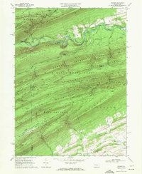
1968 Map of Weikert
USGS Topo · Published 1971About this map
Penns Creek winds through a deeply corrugated landscape of the central Pennsylvania ridge-and-valley province in the late 1960s. The settlement of Weikert and the nearby village of Pardee serve as small human anchors within the expansive Bald Eagle State Forest. The map reveals a land defined by recreational and timber history, shown through established grounds like Wesley Forest Camp, Nik-O-Mahs Camp, and Karoondinha Camp.
Find a feature on this map
74 named features on this map. Tap any name to fly to it.
Don’t see what you’re looking for? This feature index may not catch every label — zoom into the map to look around manually.
Map Details
Editions of this 1968 Weikert Map
2 editions found
Other maps of this area

1907 · Millerstown
USGS Topo · 1:62,500

1925 · Mifflintown
USGS Topo · 1:48,000

1934 · Mifflintown
USGS Topo · 1:62,500

1937 · Mifflintown
USGS Topo · 1:62,500

1937 · Millheim
USGS Topo · 1:48,000

1938 · Mifflinburg
USGS Topo · 1:48,000

1941 · Millheim
USGS Topo · 1:62,500

1943 · Millerstown
USGS Topo · 1:62,500

1943 · Mifflinburg
USGS Topo · 1:62,500

1950 · Harrisburg
USGS Topo · 1:250,000
Featured Places
- Decatur Township, PA
- Pardee, Hartley Township
- Hartley Township, PA
- Spring Township, PA
- Weikert, Hartley Township