
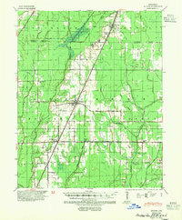
1939 Map of Weiner
USGS Topo · Published 1941About this map
The St Louis Southwestern railroad serves as the primary artery through this Poinsett County landscape, linking the established agricultural hubs of Weiner and Waldenburg. This 1930s-era survey reveals a terrain defined by extensive drainage engineering, where numerous lateral ditches and canals like Johnson Ditch and Caney Ditch manage the wetlands between the L'Anguille River and De View Bayou. The map illustrates a densely settled rural community supported by a network of local institutions, including the Beautiful Home Sch and Hickory Grove Sch. Smaller rail-side locations such as O Bear Siding and Brainard highlight the commercial reliance on the railroad for moving timber or agricultural products. To the north, the waters of Hood Lake and various sloughs like Gum Slough and Flag Slough persist amidst the developing grid of managed farm and timber land.
Find a feature on this map
41 named features on this map. Tap any name to fly to it.
Don’t see what you’re looking for? This feature index may not catch every label — zoom into the map to look around manually.
Map Details
Editions of this 1939 Weiner Map
3 editions found

Other maps of this area

1935 · Sedgwick
USGS Topo · 1:62,500

1935 · Alicia
USGS Topo · 1:62,500

1935 · Tuckerman
USGS Topo · 1:62,500

1939 · Vanndale
USGS Topo · 1:62,500

1939 · Jonesboro
USGS Topo · 1:62,500

1940 · Princedale
USGS Topo · 1:62,500

1940 · Dee
USGS Topo · 1:62,500

1940 · Tilton
USGS Topo · 1:62,500

1953 · Memphis
USGS Topo · 1:250,000

1956 · Memphis
USGS Topo · 1:250,000