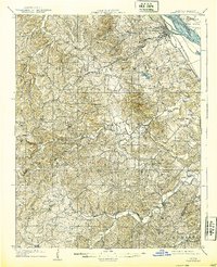
1909 Map of Weingarten
USGS Topo · Published 1939About this map
The Mississippi River defines the northeastern corner of this landscape, separating Missouri from Illinois and framing Moro Island across from the riverfront settlement of Ste Genevieve. Inland, the terrain is shaped by an intricate network of drainage, including Saline Creek and the River aux Vases, which cut through the hills of Ste Genevieve County. This early 20th-century survey reveals a rural economy dependent on the St Louis and San Francisco railroad, which connected towns like Zell and New Bourbon to the larger region.
Find a feature on this map
54 named features on this map. Tap any name to fly to it.
Don’t see what you’re looking for? This feature index may not catch every label — zoom into the map to look around manually.
Map Details
Editions of this 1909 Weingarten Map
3 editions found
Other maps of this area

1904 · Farmington
USGS Topo · 1:62,500

1906 · Farmington
USGS Topo · 1:62,500

1907 · Weingarten
USGS Topo · 1:62,500

1909 · Weingarten
USGS Topo · 1:62,500

1910 · Higdon
USGS Topo · 1:62,500

1912 · Baldwin
USGS Topo · 1:62,500

1914 · Baldwin
USGS Topo · 1:62,500

1915 · Renault
USGS Topo · 1:62,500

1915 · Chester
USGS Topo · 1:62,500

1915 · Crystal City
USGS Topo · 1:62,500