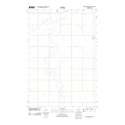
2011 Map of Weisser Dam West
USGS Topo · Published 2011About this map
Beaver Creek and the meandering South Branch Beaver Creek dominate this McIntosh County landscape, illustrating the intricate hydrology of the North Dakota prairie. This 2011 survey by the U.S. Geological Survey details a rural section of the state defined by its sectional road grid and water management features. Key landmarks include the Flickertail Dam near the northern boundary and the namesake Weisser Dam positioned to the east. The map provides a clear look at the local infrastructure, from the path of 81st St SE to 20th Ave SE, showing the placement of farmsteads and rural routes in relation to the creek's winding course. This perspective is useful for understanding early 21st-century land use and water resources in a sparsely populated agricultural region.
Find a feature on this map
15 named features on this map. Tap any name to fly to it.
Don’t see what you’re looking for? This feature index may not catch every label — zoom into the map to look around manually.
Map Details
Editions of this 2011 Weisser Dam West Map
This is the sole edition of this map. No revisions or reprints were ever made.
Other maps of this area

1953 · Jamestown
USGS Topo · 1:250,000

1954 · Bismarck
USGS Topo · 1:250,000

1956 · Jamestown
USGS Topo · 1:250,000

1958 · Bismarck
USGS Topo · 1:250,000

1979 · Schell Buttes
USGS Topo · 1:24,000

1979 · Senger Lake North
USGS Topo · 1:24,000
1979 · Senger Lake South
USGS Topo · 1:24,000

1979 · Schell Buttes SW
USGS Topo · 1:24,000
1980 · Rohrich Dam
USGS Topo · 1:24,000
1980 · Linton
USGS Topo · 1:100,000