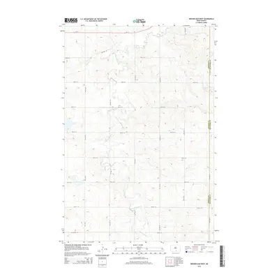
2014 Map of Weisser Dam West
USGS Topo · Published 2014About this map
The rolling hills and drainage basins along the border of Emmons Co and Mcintosh Co define this rural landscape. The primary hydrological feature is the winding path of Beaver Creek in the north, fed by the extensive network of the South Branch Beaver Creek which meanders through the central and southern portions of the territory. Agricultural land management is anchored by the Weisser Dam near the eastern boundary, a critical piece of water infrastructure for this prairie region. The area is surveyed with a precise grid of rural roads, including ND-13 traversing the northern edge and numerous section-line routes like 20th Ave SE and 85th St SE that facilitate movement between isolated farmsteads across the undulating terrain.
Find a feature on this map
19 named features on this map. Tap any name to fly to it.
Don’t see what you’re looking for? This feature index may not catch every label — zoom into the map to look around manually.
Map Details
Editions of this 2014 Weisser Dam West Map
This is the sole edition of this map. No revisions or reprints were ever made.
Other maps of this area

1953 · Jamestown
USGS Topo · 1:250,000

1954 · Bismarck
USGS Topo · 1:250,000

1956 · Jamestown
USGS Topo · 1:250,000

1958 · Bismarck
USGS Topo · 1:250,000

1979 · Schell Buttes
USGS Topo · 1:24,000

1979 · Senger Lake North
USGS Topo · 1:24,000
1979 · Senger Lake South
USGS Topo · 1:24,000

1979 · Schell Buttes SW
USGS Topo · 1:24,000
1980 · Rohrich Dam
USGS Topo · 1:24,000
1980 · Linton
USGS Topo · 1:100,000