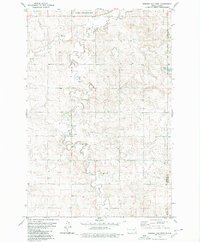
1980 Map of Weisser Dam West
USGS Topo · Published 1980About this map
Beaver Creek meanders across this prairie landscape in the late 1970s, defining a region where small rural institutions provided the foundation for local community life. The presence of St Aloysius Ch and Odessa Sch near the center of the sheet highlights the distribution of religious and educational centers serving the surrounding farmstead network. Along the northern edge, the Flickertail National Wildlife Refuge provides a protected contrast to the agricultural surroundings, while the South Branch adds further complexity to the local drainage system. The map documents a sparsely populated era in Emmons County, where the economy was punctuated by local Gravel Pits and vital water resources like Weisser Dam and scattered Wells.
Find a feature on this map
11 named features on this map. Tap any name to fly to it.
Don’t see what you’re looking for? This feature index may not catch every label — zoom into the map to look around manually.
Map Details
Editions of this 1980 Weisser Dam West Map
This is the sole edition of this map. No revisions or reprints were ever made.
Other maps of this area

1953 · Jamestown
USGS Topo · 1:250,000

1954 · Bismarck
USGS Topo · 1:250,000

1956 · Jamestown
USGS Topo · 1:250,000

1958 · Bismarck
USGS Topo · 1:250,000

1979 · Schell Buttes
USGS Topo · 1:24,000

1979 · Senger Lake North
USGS Topo · 1:24,000
1979 · Senger Lake South
USGS Topo · 1:24,000

1979 · Schell Buttes SW
USGS Topo · 1:24,000
1980 · Rohrich Dam
USGS Topo · 1:24,000
1980 · Linton
USGS Topo · 1:100,000