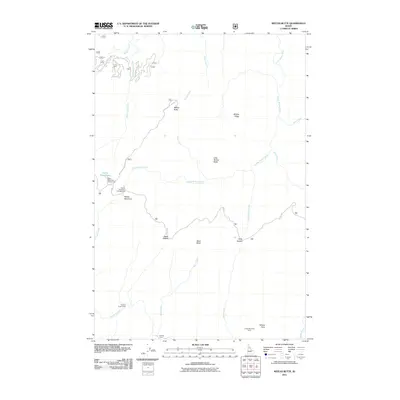
2011 Map of Weitas Butte
USGS Topo · Published 2011About this map
The Lolo Trl winds across the high Idaho backcountry on this 2011 survey, following the ridgelines through a landscape defined by seasonal camps and dramatic elevation shifts. The terrain is structured by prominent peaks like Weitas Butte and Little Weitas Butte, which overlook a complex network of drainage basins including Little Weitas Creek, Bowl Creek, and Hungery Creek. This area of the Clearwater National Forest features several established landing sites for backcountry travelers, such as Portable Soup Camp and Retreat Camp, as well as the broad Weitas Meadows. Resource management and fire suppression infrastructure are visible through designated routes like Weitas Butte Lookout Rd and several Forest Service development roads. The presence of Rocky Ridge Lake Campground and Weitas Meadows Campground indicates the area's continued use for recreation and forest access in the early 21st century.
Find a feature on this map
30 named features on this map. Tap any name to fly to it.
Don’t see what you’re looking for? This feature index may not catch every label — zoom into the map to look around manually.
Map Details
Editions of this 2011 Weitas Butte Map
This is the sole edition of this map. No revisions or reprints were ever made.
Other maps of this area

1911 · Lolo
USGS Topo · 1:250,000

1913 · Lolo
USGS Topo · 1:250,000

1923 · Washington Creek
USGS Topo · 1:125,000

1924 · Weippe
USGS Topo · 1:125,000

1956 · Hamilton
USGS Topo · 1:250,000

1959 · Hamilton
USGS Topo · 1:250,000

1960 · Hamilton
USGS Topo · 1:250,000

1964 · Hamilton
USGS Topo · 1:250,000

1965 · Lean-to Point
USGS Topo · 1:24,000
1965 · Cook Mountain
USGS Topo · 1:24,000