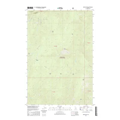
2017 Map of Weitas Butte
USGS Topo · Published 2017About this map
Clearwater National Forest encompasses this high-elevation landscape, where the historic Lolo Trl winds through the northern reaches of Idaho Co. The terrain is defined by prominent peaks and ridges including Weitas Butte, Little Weitas Butte, and Bowl Butte. A network of Forest Service infrastructure supports the area, specifically the Weitas Butte Lookout Rd and several primitive roads such as Nat For Dev Rd 103. Water features are numerous but concentrated in narrow drainages like Middle Cr, Flame Cr, and Hungery Cr. The presence of Weitas Meadows and Rocky Ridge Lake indicates natural catchments and grazing areas amidst the steep, timbered slopes. This modern survey provides a detailed view of the corridor used by Indigenous peoples and early explorers, preserved here as a managed wilderness and timber resource.
Find a feature on this map
37 named features on this map. Tap any name to fly to it.
Don’t see what you’re looking for? This feature index may not catch every label — zoom into the map to look around manually.
Map Details
Editions of this 2017 Weitas Butte Map
This is the sole edition of this map. No revisions or reprints were ever made.
Other maps of this area

1911 · Lolo
USGS Topo · 1:250,000

1913 · Lolo
USGS Topo · 1:250,000

1923 · Washington Creek
USGS Topo · 1:125,000

1924 · Weippe
USGS Topo · 1:125,000

1956 · Hamilton
USGS Topo · 1:250,000

1959 · Hamilton
USGS Topo · 1:250,000

1960 · Hamilton
USGS Topo · 1:250,000

1964 · Hamilton
USGS Topo · 1:250,000

1965 · Lean-to Point
USGS Topo · 1:24,000
1965 · Cook Mountain
USGS Topo · 1:24,000