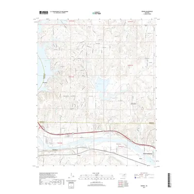
2018 Map of Wekiwa
USGS Topo · Published 2018About this map
The Arkansas River corridor west of Sand Springs defines this landscape, where the waterway meanders past Fisher Bottom and the small communities of Fisher and Lotsee. This 2018 survey captures the interface of established settlements and expanding infrastructure, notably including the Keystone Expy and William R Pogue Municipal Airport. The topography is marked by several significant impoundments, such as Shell Lake, Phillips Lake, and the eastern reaches of Keystone Lake, which dominate the western and central portions of the quadrangle. North of the river, a dense network of roads like Mayfield Rd and Chickasaw Rd serves residential clusters near Westport, while the northern boundary reaches into the hills of the Osage and Pawnee county lines. These water bodies and roadways trace the modern development of the region as it transitions from the river valley floor to the surrounding uplands.
Find a feature on this map
130 named features on this map. Tap any name to fly to it.
Don’t see what you’re looking for? This feature index may not catch every label — zoom into the map to look around manually.
Map Details
Editions of this 2018 Wekiwa Map
This is the sole edition of this map. No revisions or reprints were ever made.
Other maps of this area

1912 · Hominy
USGS Topo · 1:125,000

1915 · Hominy
USGS Topo · 1:125,000

1915 · Hominy
USGS Topo · 1:62,500

1955 · Enid
USGS Topo · 1:250,000

1956 · Sand Springs
USGS Topo · 1:24,000

1956 · Sapulpa North
USGS Topo · 1:24,000

1958 · Enid
USGS Topo · 1:250,000

1958 · Keystone Dam
USGS Topo · 1:24,000
1958 · Mannford SE
USGS Topo · 1:24,000

1958 · Wekiwa
USGS Topo · 1:24,000