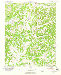
1954 Map of Welchs Creek
USGS Topo · Published 1977About this map
Welchs Creek sits at the center of this 1950s survey of Butler and Grayson Counties, where the landscape is defined by a dense network of ridges and narrow hollows. The settlement pattern is deeply connected to the topography, with small communities and churches like Flatwoods Ch and Chapel Union Ch situated atop high ground such as Flat Woods and Frog Level Ridge. This era shows a rural society still organized around local schoolhouses, including Brooklyn Sch, Dockery Sch, and the Lumbustown Sch near the southern boundary. Distinctive local landmarks like Grannys Rockhouse and Skullbone Rockhouse indicate a landscape with prominent natural outcroppings. The presence of a Strip Mine in the southwest corner near Huldeville marks the early industrial footprint of mining in this part of Kentucky, while family-named cemeteries such as Smith Cem and Gary Cem offer valuable data for genealogical research into the region’s established families.
Find a feature on this map
70 named features on this map. Tap any name to fly to it.
Don’t see what you’re looking for? This feature index may not catch every label — zoom into the map to look around manually.
Map Details
Editions of this 1954 Welchs Creek Map
2 editions found
Other maps of this area

1914 · Little Muddy
USGS Topo · 1:62,500

1922 · Leitchfield
USGS Topo · 1:48,000

1922 · Brownsville
USGS Topo · 1:62,500

1923 · Brownsville
USGS Topo · 1:62,500

1925 · Spring Lick
USGS Topo · 1:62,500

1925 · Leitchfield
USGS Topo · 1:62,500

1953 · Ready
USGS Topo · 1:24,000

1954 · Evansville
USGS Topo · 1:250,000

1954 · Spring Lick
USGS Topo · 1:24,000

1954 · Welchs Creek
USGS Topo · 1:24,000