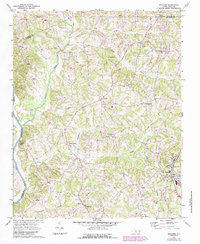
1969 Map of Welcome
USGS Topo · Published 1987About this map
The Yadkin River and its numerous tributaries, including Muddy Creek and Reedy Creek, define the rolling landscape of northern Davidson County during the late 1960s. This rural interior is characterized by a dense network of country churches that served as community anchors, such as Centenary Ch and Friedburg Ch. The Winston-Salem Southbound railroad cuts through the eastern portion of the sheet, supporting small settlements like Welcome and Arnold. In the western reaches near the river, Eureka Mills and Enterprise represent localized centers of activity. The map reveals the gradual transition of the area as residential clusters and features like the Filtration Plant and various electrical substations appear alongside long-established landmarks like the Arcadia Sch. Numerous family-named landmarks and small cemeteries provide significant detail for genealogical research in this Piedmont region.
Find a feature on this map
34 named features on this map. Tap any name to fly to it.
Don’t see what you’re looking for? This feature index may not catch every label — zoom into the map to look around manually.
Map Details
Editions of this 1969 Welcome Map
2 editions found
Other maps of this area

1949 · Eller
USGS Topo · 1:24,000

1950 · Winston-Salem West
USGS Topo · 1:24,000

1950 · Lexington East
USGS Topo · 1:24,000

1950 · Winston-Salem East
USGS Topo · 1:24,000

1950 · Lexington West
USGS Topo · 1:24,000

1950 · Churchland
USGS Topo · 1:24,000

1951 · Winston-Salem West
USGS Topo · 1:24,000

1951 · Winston-Salem East
USGS Topo · 1:24,000

1951 · Churchland
USGS Topo · 1:24,000

1951 · Lexington East
USGS Topo · 1:24,000