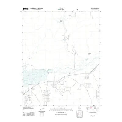
2012 Map of Weldon
USGS Topo · Published 2012About this map
The S Fork Kern River winds through the South Fork Valley, feeding into the eastern reaches of Isabella Lake in this high-desert landscape. The community of Weldon serves as a central hub, situated near the industrial remains of Brown Mill and the convergence of several rural routes like Fay Ranch Rd. To the north, the terrain transitions into canyons and flats, where agricultural footprints like the Quarter Circle 5 Ranch and natural features such as Ashley Hot Spring dot the drainage of Fay Cr. The residential patterns of South Lake and Bella Vista reflect more modern growth along the southern shores of the lake, while landmarks like Camp Fifteen and Rabbit Island highlight the importance of the water's edge to the area's development. This survey documents the intersection of ranching traditions and the recreational landscape of the Kern River valley.
Find a feature on this map
60 named features on this map. Tap any name to fly to it.
Don’t see what you’re looking for? This feature index may not catch every label — zoom into the map to look around manually.
Map Details
Editions of this 2012 Weldon Map
This is the sole edition of this map. No revisions or reprints were ever made.
Other maps of this area

1906 · Kernville
USGS Topo · 1:125,000

1908 · Kernville
USGS Topo · 1:125,000

1943 · Onyx
USGS Topo · 1:62,500

1943 · Isabella
USGS Topo · 1:62,500

1948 · Bakersfield
USGS Topo · 1:250,000

1955 · Bakersfield
USGS Topo · 1:250,000

1956 · Bakersfield
USGS Topo · 1:250,000
1956 · Kernville
USGS Topo · 1:62,500
1956 · Lamont Peak
USGS Topo · 1:62,500

1960 · Bakersfield
USGS Topo · 1:250,000