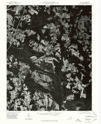
1976 Map of Weldon
USGS Topo · Published 1979About this map
Weldon and Garysburg sit on opposite banks of the Roanoke River in this 1976 orthophotoquad, which replaces traditional topographic line work with rectified aerial imagery. This perspective reveals the dense patchwork of agricultural clearings and forested corridors that defined the Halifax County landscape during the mid-1970s. The sharp contrast between the developed grids of South Weldon and the surrounding timberlands illustrates the region's concentrated settlement patterns. By using optical scanning to rectify the imagery, the U.S. Geological Survey provided a precise visual record of land use, from the winding path of the river to the specific layout of individual farmsteads and transport routes connecting these North Carolina communities.
Find a feature on this map
4 named features on this map. Tap any name to fly to it.
Don’t see what you’re looking for? This feature index may not catch every label — zoom into the map to look around manually.
Map Details
Editions of this 1976 Weldon Map
This is the sole edition of this map. No revisions or reprints were ever made.
Other maps of this area

1919 · Emporia
USGS Topo · 1:62,500

1919 · Arringdale
USGS Topo · 1:48,000

1920 · Arringdale
USGS Topo · 1:62,500

1942 · Arringdale
USGS Topo · 1:62,500

1942 · Emporia
USGS Topo · 1:62,500

1953 · Norfolk
USGS Topo · 1:250,000

1963 · Skippers
USGS Topo · 1:24,000

1963 · Barley
USGS Topo · 1:24,000
1966 · Claresville
USGS Topo · 1:24,000

1974 · Halifax
USGS Topo · 1:24,000