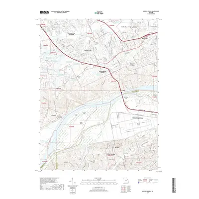
2017 Map of Weldon Spring
USGS Topo · Published 2017About this map
Howell Island and Lauer Island dominate the wide corridor of the Missouri River, marking the border between St. Charles and St. Louis counties. The landscape transitions from the river's wetland environments into the growing suburbs of O'Fallon, Weldon Spring, and Chesterfield. Family history is deeply rooted here, evidenced by numerous named burial grounds such as the Francis Howell Cem, Thomas Howell Cem, and Wolf Cem. The map shows a notable concentration of managed water bodies in the northwest, including August A Busch Lake Number 3 and numerous numbered companions. Modern infrastructure is prominent, from the Spirit of St Louis Airport in the south to the Daniel Boone Bridge spanning the river, alongside local landmarks like the Friedens German/English Evangelical Cem in Hamburg.
Find a feature on this map
81 named features on this map. Tap any name to fly to it.
Don’t see what you’re looking for? This feature index may not catch every label — zoom into the map to look around manually.
Map Details
Editions of this 2017 Weldon Spring Map
This is the sole edition of this map. No revisions or reprints were ever made.
Other maps of this area

1903 · O'Fallon
USGS Topo · 1:125,000

1931 · Manchester SE
USGS Topo · 1:24,000

1931 · Brussels
USGS Topo · 1:62,500

1932 · Manchester NE
USGS Topo · 1:24,000

1937 · Weldon Spring
USGS Topo · 1:24,000

1939 · Brussels
USGS Topo · 1:62,500

1940 · Eureka
USGS Topo · 1:24,000

1940 · Weldon Spring
USGS Topo · 1:24,000

1941 · Troy
USGS Topo · 1:62,500

1943 · Brussels
USGS Topo · 1:62,500