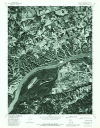
1979 Map of Weldon Spring
USGS Topo · Published 1981About this map
The Missouri River dominates the southern portion of this orthophotoquad, carving a wide path through the landscape near Weldon Spring. Captured through aerial photography in 1979, the map reveals a mosaic of agricultural fields and developing corridors in St. Charles County. To the north, Dardenne Creek winds through the bottomlands, while the settlement of Cottleville appears as a concentrated cluster of structures amid the rolling acreage. The stark black-and-white imagery provides a clear view of the land-use patterns of the late seventies, highlighting the transition from traditional farming tracts to the infrastructure and crossroads that would come to define this suburban reach west of St. Louis.
Find a feature on this map
4 named features on this map. Tap any name to fly to it.
Don’t see what you’re looking for? This feature index may not catch every label — zoom into the map to look around manually.
Map Details
Editions of this 1979 Weldon Spring Map
This is the sole edition of this map. No revisions or reprints were ever made.
Other maps of this area

1903 · O'Fallon
USGS Topo · 1:125,000

1931 · Manchester SE
USGS Topo · 1:24,000

1931 · Brussels
USGS Topo · 1:62,500

1932 · Manchester NE
USGS Topo · 1:24,000

1937 · Weldon Spring
USGS Topo · 1:24,000

1939 · Brussels
USGS Topo · 1:62,500

1940 · Eureka
USGS Topo · 1:24,000

1940 · Weldon Spring
USGS Topo · 1:24,000

1941 · Troy
USGS Topo · 1:62,500

1943 · Brussels
USGS Topo · 1:62,500