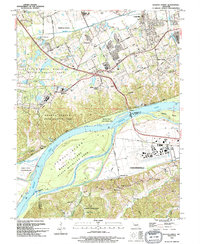
1994 Map of Weldon Spring
USGS Topo · Published 1995About this map
The Missouri River forms the central geographic feature of this mid-1990s landscape, separating St. Charles and St. Louis counties and creating a complex system of riverine islands like Howell Island and Johnson Island. The northern banks are defined by extensive conservation and management areas, including the Weldon Spring State Wildlife Area and the August A Busch Memorial State Wildlife Area. This era shows a transition from agricultural and rural use toward suburban and recreational expansion, evidenced by the development of the Katy Trail State Park along the former railroad corridor and the prominent Whitmoor Country Club. To the south, the industrial and aviation infrastructure of Chesterfield is anchored by the Spirit of St Louis Airport. Genealogists will find numerous family and parish burial grounds preserved amidst the growth, from the Howell Cem and St Josephs Cem to the Bates Cem located within Babler State Park.
Find a feature on this map
55 named features on this map. Tap any name to fly to it.
Don’t see what you’re looking for? This feature index may not catch every label — zoom into the map to look around manually.
Map Details
Editions of this 1994 Weldon Spring Map
This is the sole edition of this map. No revisions or reprints were ever made.
Other maps of this area

1903 · O'Fallon
USGS Topo · 1:125,000

1931 · Manchester SE
USGS Topo · 1:24,000

1931 · Brussels
USGS Topo · 1:62,500

1932 · Manchester NE
USGS Topo · 1:24,000

1937 · Weldon Spring
USGS Topo · 1:24,000

1939 · Brussels
USGS Topo · 1:62,500

1940 · Eureka
USGS Topo · 1:24,000

1940 · Weldon Spring
USGS Topo · 1:24,000

1941 · Troy
USGS Topo · 1:62,500

1943 · Brussels
USGS Topo · 1:62,500