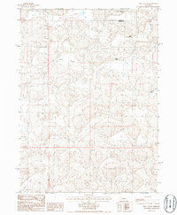
1986 Map of Well Valley
USGS Topo · Published 1986About this map
Well Valley and its surrounding ranchlands represent the remote agricultural character of the Nebraska Sandhills in the mid-1980s. This survey, straddling the Grant County and Garden County line, illustrates a landscape defined by expansive depressions and localized valleys rather than traditional town centers. These low-lying areas, including Dwire Valley, Cochran Valley, and Green Valley, provided essential grazing and water resources in an otherwise arid environment. The map documents several established ranching operations such as the Sutton Buggy Pole Ranch, Hust Ranch, and Smith Ranch. These labels offer a detailed look at land ownership and the spatial distribution of homesteads in this isolated region during the late twentieth century, which is valuable for genealogical research into these specific Nebraska ranching families.
Find a feature on this map
8 named features on this map. Tap any name to fly to it.
Don’t see what you’re looking for? This feature index may not catch every label — zoom into the map to look around manually.
Map Details
Editions of this 1986 Well Valley Map
This is the sole edition of this map. No revisions or reprints were ever made.
Other maps of this area

1948 · George Lake
USGS Topo · 1:62,500

1949 · Rackett
USGS Topo · 1:62,500

1950 · Velma
USGS Topo · 1:62,500

1950 · George Lake
USGS Topo · 1:62,500

1950 · Longfellow Lake
USGS Topo · 1:62,500

1951 · Rackett
USGS Topo · 1:62,500

1954 · Scottsbluff
USGS Topo · 1:250,000

1954 · North Platte
USGS Topo · 1:250,000

1956 · North Platte
USGS Topo · 1:250,000

1957 · North Platte
USGS Topo · 1:250,000