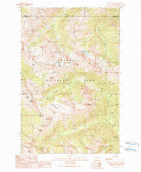
1990 Map of Wellesley Peak
USGS Topo · Published 1990About this map
Olympic National Park defines this 1990 provisional survey, which illustrates the glaciated high country along the Jefferson and Clallam county line. The landscape is dominated by the massive Mount Cameron and the sprawling Cameron Glaciers, feeding the headwaters of the Lillian River and Cameron Creek. This map captures the network of backcountry routes and sites used by mountaineers and hikers, including Bear Camp and Dose Meadow Camp, alongside prominent high-elevation passes like Grand Pass and Cameron Pass. The drainage patterns are clearly visible, showing how Knerry Creek and Butler Creek descend into the larger Dosewallips River valley. To the south, the terrain includes distinctive named points such as Sentinel Peak and Sentinels Sister, overlooking the expansive Thousand Acre Meadow. This map provides a detailed view of the alpine environment before more modern shifts in glacial coverage occurred.
Find a feature on this map
36 named features on this map. Tap any name to fly to it.
Don’t see what you’re looking for? This feature index may not catch every label — zoom into the map to look around manually.
Map Details
Editions of this 1990 Wellesley Peak Map
This is the sole edition of this map. No revisions or reprints were ever made.
Other maps of this area

1938 · Mt Constance
USGS Topo · 1:125,000

1944 · Mt. Angeles
USGS Topo · 1:62,500

1946 · Mt. Angeles
USGS Topo · 1:62,500

1946 · Tyler Peak
USGS Topo · 1:62,500

1947 · The Brothers
USGS Topo · 1:62,500

1947 · Mt. Steel
USGS Topo · 1:62,500

1948 · Tyler Peak
USGS Topo · 1:62,500

1950 · The Brothers
USGS Topo · 1:62,500

1950 · Mt. Steel
USGS Topo · 1:62,500

1958 · Seattle
USGS Topo · 1:250,000